September 28, 2026 Post by : Editorial Landscape Evolution
Meltwater Channels: The Rivers That Ran on Top of Ice Sheets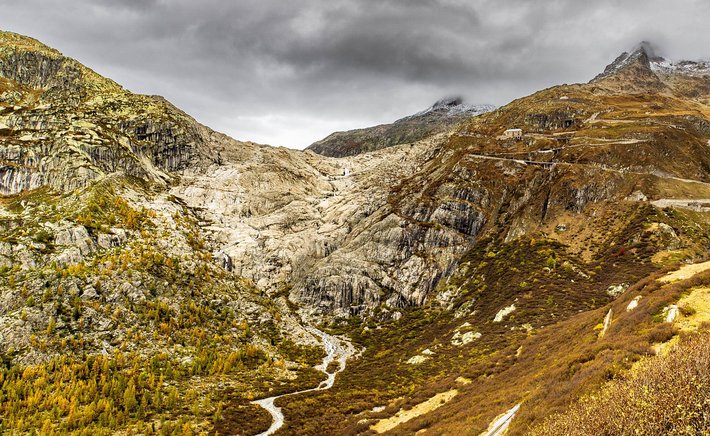
Compare a river-carved valley with a glacier-carved valley and the difference is striking. Rivers cut narrow, V-shaped gorges as they downcut into bedrock. Glaciers, by contrast, grind away the sides as well as the floor, producing broad valleys with steep walls and flat bottoms — the classic U-shape. Understanding why requires thinking about how ice erodes rock very differently from flowing water.
A glacier is essentially a slow-moving river of ice, but it carries tools that water alone cannot. As ice flows over bedrock, it plucks loose blocks and drags embedded rocks across the surface like sandpaper. This combination of abrasion and quarrying smooths and widens the valley. The result is a trough with a parabolic cross-section, often with polished rock surfaces and linear scratches called striations that record the direction of ice flow.
Hanging Valleys and Truncated Spurs
U-shaped valleys rarely occur in isolation. Where a smaller tributary glacier met a larger trunk glacier, the trunk eroded its floor much more deeply. When the ice melted, the tributary valley was left perched high above the main valley, forming what geographers call a hanging valley. Waterfalls often tumble from these hanging valleys today, as at Yosemite and in the Norwegian fjords.
Another signature feature is the truncated spur. In a river valley, ridges alternate from side to side in an interlocking pattern. In a glacial trough, the advancing ice shears off these projecting ridges, leaving steep triangular cliffs along the valley walls. Together with hanging valleys, truncated spurs create the dramatic, almost architectural profiles that make glacial valleys so photogenic.
Where a glacier reached the sea, its trough may have been drowned by rising post-glacial sea levels, producing a fjord. These deep, steep-sided inlets — found in Norway, Chile, New Zealand, and Greenland — are simply U-shaped valleys with saltwater in them. Their depth often exceeds that of the adjacent continental shelf, a testament to the erosive power of ice.
Reading the Shape of the Land
For geographers, valley cross-profiles are a quick diagnostic tool. A V-shape points to fluvial erosion, while a U-shape points to glacial erosion. Valley floor width, wall steepness, and the presence of features like hanging valleys and truncated spurs all help confirm the interpretation. On a topographic map, glacial valleys often appear as broad, straight troughs with parallel contour lines on either side.
Glacial valleys also shape human geography. Their flat floors attract roads, railways, and settlements, while their steep walls limit agriculture and create natural boundaries. Learning to recognise them is not just an academic exercise — it is a way of understanding why mountain communities are arranged the way they are.
Author

22 feb,2025
This incident opened my eyes to the value of Insurance in general, so I decided to examine my personal and business insurance.

Comment (3)
The payments are made directly from one person to another without passing through a central bank or clearing house.
22 feb,2025
ReplyMoraines, Eskers, and Kames: A Field Guide to Glacial Deposits
23 feb,2025
ReplyThe Geography of U-Shaped Valleys: How Glaciers Carve Mountains
23 feb,2025
Reply