October 4, 2026 Post by : Editorial Glacial Landforms
Erratics and Striations: Reading the Fingerprints of Ancient Ice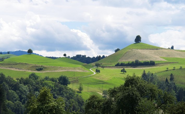
If you have ever driven through the countryside of Ireland, upstate New York, or southern Ontario and noticed a peculiar pattern of smooth, egg-shaped hills arranged like a basket of loaves, you have encountered drumlins. These landforms are among the most recognizable fingerprints left behind by continental ice sheets, and they tell a surprisingly detailed story about the behaviour of glaciers that vanished thousands of years ago.
A drumlin is a streamlined hill, typically composed of till — a chaotic mixture of clay, sand, gravel, and boulders that was scraped up and redistributed by moving ice. Most drumlins are between 10 and 50 metres high and a few hundred metres long, though some giants reach over a kilometre. Their classic shape is blunt and steep at one end and tapered at the other, and that asymmetry is the key to reading them. The steep end faces the direction the ice came from, while the tapered tail points downstream, like a stone smoothed by a river current.
Why Drumlins Form in Swarms
Drumlins rarely appear alone. They cluster in groups called drumlin fields, sometimes numbering in the thousands. The famous drumlin belt of Ireland stretches across the northern midlands, and the landscape around Boston and Wisconsin is similarly dotted with these hills. Geologists debate exactly how they form. Some argue that ice repeatedly moulded and reshaped soft till beneath it, while others suggest that meltwater floods or subglacial deformation played a bigger role. What most researchers agree on is that drumlins form at the base of warm-based ice sheets — glaciers thick enough and wet enough at their bed to slide and deform the sediment beneath them.
Because drumlins are streamlined, they act as compass needles for palaeo-glaciology. By mapping the long axes of thousands of drumlins, scientists can reconstruct the flow paths of ice that melted away long before anyone was around to observe it. In this sense, a drumlin field is a fossilized map of an ice sheet's internal plumbing.
Reading a Drumlin Landscape Today
For the casual observer, drumlins are a pleasure to explore. Their well-drained, often fertile soils made them attractive for farming, and many have been cleared of forest for centuries. In Ireland they are sometimes called 'basket hills' because of their resemblance to woven creels. Walkers notice them as gentle swells in otherwise flat lowlands, and geographers use them to teach principles of ice flow, sediment transport, and landscape evolution.
Next time you stand on a rounded hill in a northern landscape, look around at its neighbours. If they line up with a common orientation, you may be standing on a drumlin, and the ice that shaped it once flowed right over your boots.

Author

22 feb,2025
This incident opened my eyes to the value of Insurance in general, so I decided to examine my personal and business insurance.



Comment (3)
The payments are made directly from one person to another without passing through a central bank or clearing house.
22 feb,2025
ReplyMeltwater Channels: The Rivers That Ran on Top of Ice Sheets
23 feb,2025
ReplyCirques: The Armchair-Shaped Hollows Where Glaciers Are Born
23 feb,2025
Reply